Synopsis:.
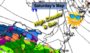
The weekend will be a 50/50 split. High pressure over Eastern Canada will dominate our weather for today-high clouds will filter the sun. It’ll be chilly. Readings will be several degrees below the average high of 49º.
Thickening clouds tonight. All readings will be below freezing.
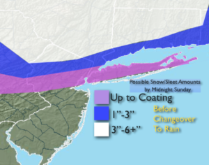
Sunday will go downhill quickly. A storm over the midwest will begin to transfer it’s energy to a developing low pressure over the Delmarva Peninsula. There will be enough cold air at the onset for a snow/mix for much of the area beginning Sunday morning. Mainly rain is expected for Ocean county. Warmer air will work in as the storm intensifies just East of New Jersey. This will cause most of the frozen precipitation to go over to rain. The exception is areas to the North and West. Snow, sleet and freezing rain will likely continue. Here an accumulation is quite likely. Potential snow/sleet amounts by Sunday Midnight are posted above (2nd map). These amounts are not etched in stone and will change.
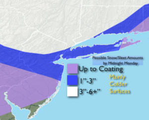
As the upper low swings to the coast it will capture the surface storm and redevelop it South of Long Island. This upper level feature will bring down cold air. Periods of rain changing to snow is likely. The heaviest precipitation looks to fall North & West of the City. Here the potential for accumulating snow is likely. At this time, the City and coast may receive a minor accumulation. Potential snow amounts by Monday Midnight are posted above (3rd map). These amounts are not etched in stone and will change.
Behind the storm the sun will return on Tuesday and Wednesday.
Stay Tuned.
Keep it here for a no hype, no nonsense forecast.
Today:
Sunshine filtered through high clouds. Chilly. Highs in the lower 40s. Northwest winds at 5-10mph.
Tonight:
Thickening clouds. Cold. Lows around freezing in the urban corridor, the teens and 20s inland. Northwest to Northeast winds at 5-10mph.
Sunday:
A mix of snow, sleet and freezing rain and rain in the morning (depending on your location). Most areas will go over to rain. North and West a mix will continue. Highs in the 30s. 4os over South Central NJ.
Monday:
Mixed precipitation going over to periods of wet snow. Steadiest and heaviest precipitation will be North and West. Highs in the 30s.
Tuesday:
Partly sunny, breezy and cool. Highs around 40º.
Wednesday:
Partly sunny.. Highs in the lower 40s.