Synopsis:.
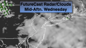
High pressure off the coast will result in a mild Southerly wind through today. Readings will be well above the average high of 50º. Getaway day Wednesday will feature more clouds than sun as cool front will approach. Scattered showers are likely mainly from midday on. There will be dry times.
Thanksgiving will be cooler and windy under a mix of sun and clouds. A strong Northwest flow will be with us do to a powerful Canadian maritime storm and strong high pressure over Central Canada. The weather will cooperate for shoppers on Black Friday despite the chill.
High pressure over Eastern Canada will dominate our weather for the beginning of the weekend. Saturday will feature plenty of sun and will be the better half of the weekend.
There will be a developing storm for the Mid-Atlantic coast for the second half of the weekend. There is the potential for a mix of rain and snow developing late Saturday night. On Sunday enough warm air should work into the area for mainly rain along the coast. Even inland the mix most likely will go over to rain.
Stay Tuned.
Keep it here for a no hype, no nonsense forecast.
Wednesday (Getaway Day):
Mostly cloudy and mild. Scattered showers are likely mainly in the afternoon. Highs in the mid to upper 50s. East to South winds at 5-10mph.
Tonight:
Becoming partly cloudy and windy. Lows in the 40s throughout. West winds increasing to 15-30mph with higher gusts late.
Thanksgiving:
Partly sunny, windy and cooler. Highs around 50º with readings falling during the afternoon.
Friday:
Mostly sunny, breezy and chilly. Highs in the mid 40s.
Saturday:
Partly sunny. Chilly. Highs in the lower 40s.
Saturday:
Rain along the coast. Mix of snow and rain inland going over to rain. Highs around 40º.