
Synopsis:.
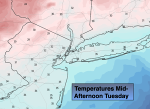
A significant cold front will approach the region this morning. Morning showers have a decent chance of changing to snow showers as cold air comes rushing in during the mid to late morning hours. At this point this doesn’t look like a major concern with the white stuff. There is the potential for a dusting or coating of snow in spots and on colder surfaces. The sun will return during the afternoon. Temperatures will drop from morning highs in the 40s & 50s into the 30s and winds will increase.
The coldest airmass of the season so far will be will be upon us Tuesday night and Wednesday as Canadian high pressure works in. Record lows are possible for Wednesday. The forecast is for 21º at Central Park Wednesday morning, the record is 24º set in 1986. Gather up that firewood!
The weather looks to cooperate for the end of the week as high pressure dominates the Mid-Atlantic. Readings will recover slowly to near 50º by Friday. At least the sun will be shining.
Stay Tuned.
Keep it here for a no hype, no nonsense forecast.
Today:
Morning showers mostly likely changing to snow showers. Becoming mostly sunny and breezy by early to mid afternoon. Early morning highs in the 40s and 50s. Temperatures will tumble into the 30s by mid to late morning and stay in the 30s throughout the day. Becoming windy. Increasing West to Northwesterly winds at 15-30mph with gusts to 35mph.
Tonight:
Clear, windy and frigid for mid November. Lows in the lower 20s in the City, the teens elsewhere. Northwest winds at 15-30mph with gusts to 35mph. Wind chills will be in the single digits and teens. The winds will diminish after midnight.
Wednesday:
Mostly sunny, breezy and cold. Highs only in the lower to mid 30s.
Thursday:
Mostly sunny. Chilly. Highs around 40º.
Friday:
Mostly sunny. Highs around 50º.
Saturday:
Mostly sunny. Colder. Highs around 40º.