Synopsis:
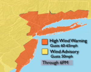
The storm that gave us the heavy rain yesterday is now a wind maker for the region. This is the big story. High Wind Warnings and Advisories are up for the entire tri-state area (map above). Winds could gusts 50 to 60mph in many areas. This could cause scattered power outages and downed trees. The intense low is over Eastern New England. we’ll get to dry out under a mix of clouds and sun, but a spot shower can’t be ruled out.
Friday will be chilly with a cool pool of air over the Northeast in the wake of the departing low. Winds will abate some.
A nice weekend is on the way! Both days will feature plenty of sun and seasonal readings as high pressure dominates.
Stay Tuned.
Keep it here for a no nonsense, no hype forecast.
Today:
More clouds than sun, windy and cooler. Spotty showers can’t be ruled out. Highs in the upper 50s. West winds at 15-30mph with gusts 50-65mph.
Tonight:
Partly cloudy, windy and cool. Lows in the 40s throughout. West winds at 15-30mph with gusts to 45mph early then diminishing.
Friday:
Sun and clouds. Windy and chilly. Highs in the upper 50s.
Saturday:
Sunny and seasonal Highs in the mid 60s.
Sunday:
Sun to late day clouds. Highs in the mid to upper 60s.
Monday:
Clouds, some sun. A few showers are possible. Highs in the mid to upper 60s.