Synopsis:
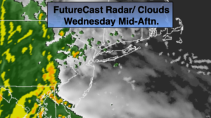
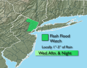
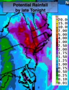
Low pressure will move toward the region today. Any early morning sun will give way to thickening clouds. Spotty showers are possible before steady rain develops by midday over Western areas to mid to late afternoon farther to the East. The low will deepen rapidly at our latitude. Whether the storm’s track is just inland, hugs the coast or is just offshore a period of heavy rain is likely for the PM commute into early tonight. One to three inches of rain is possible by late tonight (3rd map above) and a Flash Flood Watch is up for Northeastern NJ. Local street and highway flooding is likely. Winds may be gusty along the coast and over Central and Eastern Long Island. Some gusts may reach 40-50mph during the evening.
The rain will taper off from Southwest to Northeast tonight. Winds will be strong out of the Northwest.
As the storm moves into Eastern New England on Thursday we’ll dry out, but winds will be gusty out of the West and Northwest. Highs may remain in the 50s with winds gusting to 40mph.
Friday will be chilly with a cool pool of air over the Northeast in the wake of the departing low. Winds will abate some.
A nice weekend is on the way! Both days will feature plenty of sun and seasonal readings.
Stay Tuned.
Keep it here for a no nonsense, no hype forecast.
Today:
Early morning sun giving way to thickening clouds. Spotty showers are possible toward midday. Rain will develop between midday to mid afternoon. The rain could be heavy at times late. Becoming windy along the coast. East to Southeast winds at 10-20mph with gust to 40+mph late. Highs in the mid 60s.
Tonight:
A period of heavy rain. Rain tapers off late. Lows in the 40s throughout. Winds becoming Northwest at 15-30mph with gusts to 45mph.
Thursday:
Sun and clouds. Windy and cooler. Highs in the upper 50s.
Friday:
Sun and clouds. Windy and chilly. Highs in the upper 50s.
Saturday:
Sunny and seasonal Highs in the lower to mid 60s.
Sunday:
Sunny. Highs in the mid to upper 60s.