Synopsis:
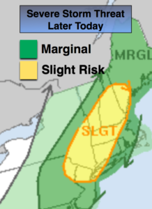
Today will be warmer and more humid with a Southwesterly flow. A mix of sun and clouds is expected. A cool front will approach late day with scattered showers and thunderstorms. Keep an eye to the sky after 3PM. Some of the storm maybe severe. Severe thunderstorms contain one of the following criteria: winds in excess of 58mph and or one inch hail.
Once the activity moves offshore this evening. It’ll be cooler and less humid overnight under partly cloudy skies.
Thursday will be mostly sunny. A few high clouds may roll in from the South. It’ll be comfortable.
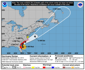
Hurricane Dorian should track up and off our coast on Friday and Friday night. There is a chance of some rain as the hurricane makes it’s closest approach but we shouldn’t experience severe conditions. The best chance of rain will be along the coast. Winds will be gusty, especially at the coast. Please check back to JMW for the very latest for our area.
Category 2 Hurricane Dorian is off the Northern Florida coast with 110mph sustained winds as of this writing. The hurricane is moving to the North/Northwest and will parallel the Florida coast just far enough to spare the region of significant damage.Residents should never let their guard down until the hurricane is North of their latitude as any deviation in the track to the West will result in the situation becoming dire rapidly (but this isn’t likely).
The potential storm track continues a Northeast motion up and just off the Georgia and Carolina coastline Wednesday and Thursday. Once again a little shift to the West could mean perilous situation for the Carolina’s and a possible landfall. The hurricane then gets off our coastline on Friday and Friday night. A period of rain and wind is possible if the bands are close enough. The best chance is for coastal areas and Long Island. Dorian looks to stay far enough offshore to spare our area of its menacing affects.
Stay Tuned.
Keep it here for a no nonsense, no hype forecast.
Today:
Partly sunny, warm and more humid. Scattered showers and storms are possible by mid to late afternoon. Highs in the mid 80s. Southwest winds at 10-20mph.
Tonight:
Early scattered showers and storms, otherwise partly cloudy and less humid by morning. Lows in the mid 60s in the City, the mid 50s inland. Winds becoming North at 8-12mph.
Thursday:
Mostly sunny, much cooler and less humid. Highs only in the mid 70s.
Friday:
Clouds some sun. A period of rain and wind is possible, especially at the coast and to the East. Highs only around 70º.
Saturday:
Partly sunny. Highs in the upper 70s.
Sunday:
Mostly sunny. Highs in the upper 70s.