Synopsis:
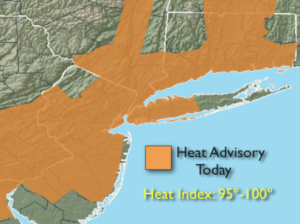
The Bermuda high will remained anchored off the US coast through Thursday. This system will be responsible for the tropical feel the next several days. A Heat Advisory is up for most of the tri-state area today for the combination of the heat and humidity making it feel near 100º. Please drink plenty of fluids and limited outdoor activity if possible during the heat of the day. A stray PM storm can’t be ruled out each and every day but most of the time will be rain free. Low clouds and patchy fog will greet us most mornings. The grey will break for hazy sun. 90 degree readings will be common through Thursday. A cool front is expected to move through by late Thursday. This is the day for the best chance of thunderstorms. Relief will arrive by Friday!
Stay cool!
Keep it here for a no nonsense, no hype forecast.
Today:
Hazy, hot and humid. Stray PM storm. Highs near 90º. South winds at 5-10mph.
Tonight:
A stray evening storm, otherwise mostly cloudy, warm and muggy . Lows in the lower 70s in the City, the 60s elsewhere. Light and variable winds.
Tuesday:
Hazy, very warm and humid. Stray PM storm. Highs in the 80s to near 90º.
Wednesday:
Hazy, hot and humid. A stray PM storm. Highs in the 80s near 90º.
Thursday:
Hazy, very warm and humid. A greater risk of PM storms. Highs in the 80s near 90º.
Friday:
Partly sunny, much cooler and less humid. Highs around 80º.