Synopsis:
It’ll be a bright, warm but comfortable start to the workweek. The humidity will be low as a dry airmass works in from Canada. This will be the most comfortable day of the week.
Very warm to hot conditions and increasingly humid conditions will develop with a Southwesterly wind as a Bermuda high pressure builds through the week. A few rounds of storms are possible. One with the remnants of Barry Wednesday night and the second round with a warm (hot) front Thursday night.
The potential is there for intense heat as we head into Friday and the weekend. A heatwave is likely. A heatwave is defined as three consecutive days at 90º or above.
Stay tuned.
Keep it here for a no nonsense, no hype forecast.
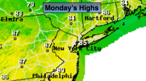
Today:
Sunny, low humidity. Highs in the mid 80s. Northwest to West winds at 5-10mph.
Tonight:
Clear and comfortable. Lows in the lower 70s in urban areas, the upper 50s to 60s inland. Northwest winds less than 5mph.
Tuesday:
Mostly sunny, hot. Highs near 90º.
Wednesday:
Hazy, hot and humid. Spotty PM storms. Highs in the lower 90s.
Thursday:
Hazy, hot and humid. Spotty PM storms. Highs in the lower 90s.
Friday:
Hazy, hot and humid. Highs in the mid to upper 90s. Heat index 100º to 110º