Synopsis:
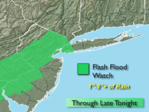
The humidity will be at uncomfortable levels today ahead of a weak cool front that will be approaching from the West. Hazy sun and clouds are expected. Scattered areas of rain and storms will move in from the West this afternoon. Some of the storms may contain torrential rain. A Flash Flood Watch is up for all of New York City and most of NJ (map above) into late tonight. If you encounter a flooded roadway-TURN AROUND, DON’T DROWN. Morning clouds will give way to sun on Friday. It’ll still be humid and very warm.
The weekend will be sunny but hot as high pressure settles over the region.
Stay tuned.
Keep it here for a no nonsense, no hype forecast.
Today:
Hazy, warm and humid. Chance of late day storms. Highs in the mid 80s. South to Southeast winds at 8-12mph.
Tonight:
Scattered showers and storms. Muggy. Lows in the lower 70s in the City, the upper 60s inland. Southeast to Southwest winds at 5mph..
Friday:
Morning clouds will give way to partly sunny skies. Highs in the mid to upper 80s.
Saturday:
Sunny and hot. Highs around 90º.
Sunday:
Sunny and hot. Highs around 90º.
Monday:
Mostly sunny. Highs in the upper 80s.