Synopsis:
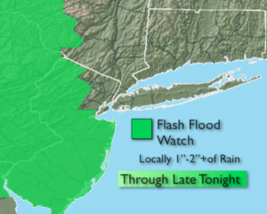
Eye to the sky for threatening weather into this evening. Scattered strong to severe thunderstorms will move through the area as a trough of low pressure works in. Severe thunderstorms contain the following criteria: winds in excess of 58mph and or one inch hail. A Flash Flood Watch is back in effect for parts of NJ (map above). If you encounter a flooded roadway- TURN AROUND, DON’T DROWN.
Our stretch of miserable weather will be coming to an end. I guess we can say good riddance to Spring. Summer arrives tomorrow at 11:54am EDT and conditions will be improving right around that time! The sun will return during the afternoon hours and the humidity will lower dramatically.
The first weekend of Summer will be spectacular. Sunny skies, warm temperatures and low humidity will be with us as high pressure moves in.
Summery weather will greet us for the beginning of the workweek.
Stay tuned.
Keep it here for a no nonsense, no hype forecast.
Tonight:
Scattered showers and thunderstorms. Some of the storms may be severe this evening. There will be areas of torrential rain . Lows in the 60s throughout. Winds becoming Northwest at 5-10mph.
Friday:
Threat of morning showers, otherwise becoming mostly sunny during the afternoon. Less humid. Highs in the upper 70s.
Saturday:
Sunny. Low humidity. Highs around 80º.
Sunday:
Mostly sunny. Highs in the lower 80s.
Monday:
Partly sunny. Warmer and more humid. Highs in the mid 80s.
Tuesday:
Hazy, warm and humid. Spotty storms. Highs in the lower to mid 80s.