Synopsis:
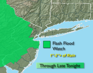
The broken record forecast continues. The threat of scattered showers and storms will be with us through early Friday as a stationary front continues to make it’s home over the region. The rain maybe torrential at times. The timing for the areas of heavy rain looks to be later today and early tonight. A Flash Flood Watch is back in effect for parts of NJ (1st map above). If you encounter a flooded roadway- TURN AROUND, DON’T DROWN. It won’t be raining constantly the next two days and the sun will shine from time to time.
A cool front will finally move through and break the pattern by Friday, the first day of Summer. Morning rain should give way to afternoon sun.
The first weekend of Summer will be spectacular. Sunny skies, warm temperatures and low humidity will be with us as high pressure moves in.
Stay tuned.
Keep it here for a no nonsense, no hype forecast.
Today:
Mostly cloudy with scattered showers. Areas of torrential rain later today. Highs in the lower to mid 70s. Northeast to Southeast winds at 5-10mph.
Tonight:
Scattered showers and storms early. Heavy rain in spots. Lows in the 60s throughout. Light East winds.
Thursday:
Partly sunny. More humid. Isolated PM storms. Highs around 80º.
Friday:
Threat of morning showers, otherwise becoming mostly sunny during the afternoon. Less humid. Highs in the upper 70s.
Saturday:
Sunny. Low humidity. Highs around 80º.
Sunday:
Mostly sunny. Highs around 80º.