Synopsis:
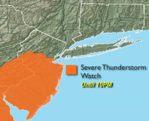
*** Severe Thunderstorm Watch until 10pm for Central & Southern NJ-refer to 1st map above*** Some of the storms South of the City may become severe. The criteria for a severe thunderstorm is the following: winds in excess of 58mph and or one inch hail. Keep an eye to the sky for threatening weather conditions and seek shelter immediately if need be.
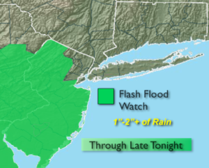
There is the potential for heavy rain. This may cause a concern for flash flooding. A Flash Flood watch is up for Sussex, Warren, Morris, Hunterdon, Somerset, Middlesex, Monmouth and Ocean counties through late tonight. One to two inches of rain is possible. If you encounter a flooded roadway, turn around-don’t drown.
It’s the same ol’ story. The threat of scattered showers and storms will be with us through the majority of the week as a stationary front makes it home over the region. It won’t be raining constantly and the sun will shine from time to time.
A cool front will finally move through and break the pattern by Friday, the first day of Summer. Morning rain should give way to afternoon sun.
The first weekend of Summer will be spectacular. Sunny skies, warm temperatures and low humidity will be with us.
Stay tuned.
Keep it here for a no nonsense, no hype forecast.
Into this Evening & Tonight:
Areas of rain and thunderstorms (locally severe early on to the South of the City). Torrential rain is also likely in spots, otherwise a chance of showers after midnight. Lows in the 60s throughout. Northeast to North winds at 5mph.
Wednesday:
Mostly cloudy with scattered showers. Highs in the lower to mid 70s.
Thursday:
Partly sunny. More humid. Isolated PM storms. Highs around 80º.
Friday:
Threat of morning rain, otherwise becoming partly sunny during the afternoon. Highs in the upper 70s.
Saturday:
Sunny. Low humidity. Highs around 80º.
Sunday:
Mostly sunny. Highs around 80º.