
Synopsis:
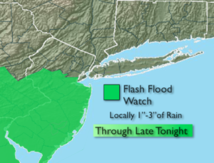
The threat of scattered showers and storms will be with us through the majority of the week as a stationary front gets hung up over the region. It won’t be raining constantly and the sun will shine from time to time. The potential of heavy rainfall is there. This may cause a concern for flash flooding. A Flash Flood watch is up for Hunterdon, Somerset, Middlesex, Monmouth and Ocean counties through late tonight. One to two inches of rain is possible. If you encounter a flooded roadway, turn around-don’t drown.
A cool front will finally move through and break the pattern by Friday, the first day of Summer. Morning rain should give way to afternoon sun.
Saturday will be spectacular (I know, we have days until we get there).
Stay tuned.
Keep it here for a no nonsense, no hype forecast.
Tonight:
Humid. On and off rain. Scattered thunderstorms, mainly to the South. The rain could be heavy at times. Lows in the 60s throughout. Southeast to Northeast winds at 5mph.
Tuesday:
Mostly cloudy with scattered showers. Highs in the lower to mid 70s.
Wednesday:
Mostly cloudy with scattered showers. Highs in the mid 70s.
Thursday:
Partly sunny. More humid. Isolated PM storms. Highs around 80º.
Friday:
Threat of morning rain, otherwise becoming partly sunny during the afternoon. Highs around 80º.
Saturday:
Sunny. Low humidity. Highs around 80º.