Synopsis:
Scattered showers and storms will move in this evening and continue through the midnight hour as a weak disturbance works through from the West. Not all areas will get in on the action.
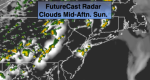
Sunday will start off with sun. Showers and storms are likely later in the afternoon and evening as a cool front approaches. Some of the storms on Sunday could be severe.
Monday and Tuesday will be bright and cool for the beginning of June as a cool pool of air works in from Canada.
A Southwest flow will develop on Wednesday and Thursday as high pressure settles over the Southeast. This will result in readings once again at or above 80º.
Happy June!
Keep it here for a no nonsense, no hype forecast.
The 2019 hurricane season begins today. Here is a list of the Atlantic storm names:

Tonight:
Scattered showers and storms until a few hour after midnight, otherwise partly cloudy. Lows in the lower 60s in the City, the upper 50s inland. Light and variable winds.
Sunday:
Sun and clouds. Scattered mid-afternoon showers and storms. Highs in the upper 70s. South winds at 8-12mph.
Monday:
Partly sunny, cooler and breezy. Highs in the upper 60s.
Tuesday:
Mostly sunny. Highs in the lower 70s.
Wednesday:
Partly sunny. Warmer. Scattered late day storms. Highs around 80º.
Thursday:
Partly sunny. Warm. Scattered late day storms. Highs in the lower 80s.