Synopsis:
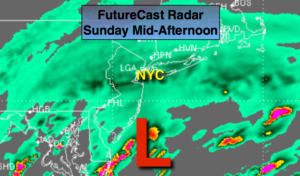
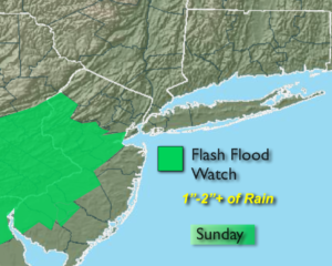
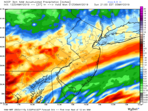
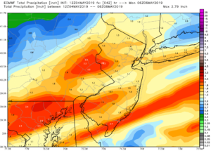
An area of low pressure will move from the Mid-Atlantic to just Southeast of the City by Sunday evening. It will be a Sunday soaker. Rain will be heavy at times in the morning into early afternoon. The heaviest rain will fall over Western and Southern areas. A Flash Flood Watch has been posted for Warren, Hunterdon, Somerset, Middlesex and Mercer Counties on Sunday. The potential for one to two inches or more of rain is likely. The 3rd and 4th maps above are the NAM 3km and the European. Both decent rain amounts by this evening. The rain should lighten up later in the day.
We’ll dry out for the beginning of the workweek as high pressure develops along the Eastern Seaboard. A mix of sun and clouds is expected with readings in the 70s Monday and Tuesday. Temperatures will be more seasonal by Wednesday.
The next chance of showers will be later Thursday.
Stay tuned.
Keep it here for a no nonsense, no hype forecast.
Today:
Rain, heavy at times through earl afternoon. Highs in the upper 50s to lower 60s. Northeast winds at 10-20mph.
Tonight:
Any showers will end early, otherwise remaining mostly cloudy. Lows in the lower 50s in the City, the 40s inland. Northeast winds diminishing to 5-10mph.
Monday:
Partly sunny. Mild. Highs around 70º.
Tuesday:
Partly sunny. Warmer. Highs in the mid 70s.
Wednesday:
Partly sunny. Seasonal Highs in the upper 60s.
Thursday:
Partly sunny. Chance of afternoon showers. Highs around 70º.