
Synopsis:
A stationary front just to our South will result in a mainly grey Saturday with areas of morning fog. Scattered showers are possible. Much of the time will be dry. Peeks of sun are possible this afternoon (1st map above). Today will be the better half of the weekend. Highs will be near the seasonal averages of the upper 60s. It’ll be cooler by the coast.
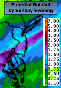
An area of low pressure will develop over the Southern Mid-Atlantic tonight and move just South of the City during the day Sunday. Spotty showers overnight tonight will become a steadier light rain before sunrise. Rain will continue Sunday and will be moderate to heavy at times through early afternoon. The heaviest rain will fall over central and Southern NJ. The potential is there for an inch or so of rain to fall with up to two inches over Southern NJ (2nd map above). The rain should lighten up later in the day.
We’ll dry out for the beginning of the workweek as high pressure develops along the Eastern Seaboard. A mix of sun and clouds is expected with readings in the 70s Monday and Tuesday. Temperatures will be more seasonal by Wednesday.
Stay tuned.
Keep it here for a no nonsense, no hype forecast.
Today:
Areas of morning fog, otherwise more clouds than sun. Chance of spotty showers. Highs in the mid to upper 60s. The lower 70s over Southern areas. Northeast winds at 5mph.
Tonight:
Cloudy. Scattered showers becoming a steady light rain before sunrise. Lows in the lower to mid 50s throughout. Northeast winds less than 5mph.
Sunday:
Rain likely. Highs in the lower 60s.
Monday:
Partly sunny. Mild. Highs in the lower 70s.
Tuesday:
Partly sunny. Warmer. Highs in the mid 70s.
Wednesday:
Partly sunny. Seasonal Highs in the upper 60s.t