Synopsis:
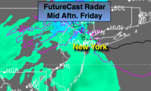
High pressure off the New England coast combined with an approaching warm front will result in a dreary, damp and chilly Friday. Spotty showers will develop this morning. Many areas will remain dry. Steadier rain will work in this afternoon. It will be cold enough well North and West for a bit of snow and or sleet, so don’t be surprised. Temperatures will be at least fifteen degrees below the average high of 57º (not feeling like April 5th). Rain will continue tonight.
At this time the weekend looks to start off with clouds on Saturday morning with early showers. The clouds should break for some sun on Saturday. Sunday will feature plenty of sun. Both days will be mild with readings several degrees above the average as high pressure moves to the area.
Monday will be wet as another system approaches from the West. The week ahead looks mild.
Keep it here for a no nonsense, no hype forecast.
Today:
Cloudy. Spotty AM showers. Steadier rain developing by afternoon. A bit of snow or sleet may fall well inland. Chilly. Highs in the lower 40s, the 30s inland. East wind at 5-10mph.
Tonight:
Rain. Lows in the 30s throughout. East to Northwest winds at 5mph.
Saturday:
Early morning showers and clouds will give way to some sun. Mild. Highs in the mid 60s.
Sunday:
Sunny. Highs in the mid 60s.
Monday:
Rain likely. Highs in the lower 60s.
Tuesday:
Clouds and sun. Scattered shower. Highs in the mid 60s.