Synopsis:
A storm will move from off the North Carolina coast tonight to East of New England Wednesday. A period of rain is likely along the coast tonight. It is possible that the shield of rain works West into some inland areas at its closest approach, although most inland areas should remain dry. Early Wednesday morning Eastern Long Island and Eastern CT will have rain but it will rapidly taper off. The storm will be out to sea and the sun will return with mild readings.
Winds will become gusty out of the West on Wednesday. Humidity levels will be low. Gusty winds and very dry air will create conditions that may promote the rapid spread of wildfires. A Fire Weather Watch has been issued for areas West of NYC. Please use caution with flammables outdoors.
High pressure will once again take control from the North and West on Thursday resulting in a fine day.
A flow off the ocean and moisture working up from the South will cause showers to develop on Friday.
At this time the weekend looks decent with a mix of sun and clouds and mild readings.
Keep it here for a no nonsense, no hype forecast.
Tonight:
Cloudy. A period of rain is likely along the coast. Rain may fall farther inland for a few hours. Lows in the mid to upper 30s to around 40º. East to Northwest winds increasing to 10-20mph with higher gusts along the coast.
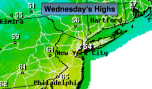
Wednesday:
Early morning rain over Eastern sections, otherwise mostly sunny. Windy and mild. Highs in the mid 60s. West to Northwest winds at 15-25mph with gusts to 35mph.
Thursday:
Mostly sunny. Highs in the upper 50s.
Friday:
Mostly cloudy. Scattered showers. Highs around 50º.
Saturday:
Clouds and sun. Highs in the lower to mid 60s.
Sunday:
Partly sunny. Highs in the lower to mid 60s.