Synopsis:
March is a fickle month. Yesterday temperatures felt like late May. By tonight, readings will be at or below freezing (I guess the only thing that would make it complete would be snow, but that’s not happening this weekend!)
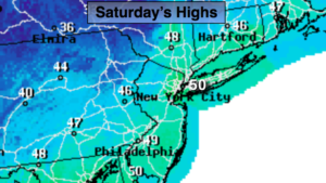
The upcoming weekend looks quiet as high pressure moves toward the East coast. The sun will rule the sky. Readings today will be near the average high of 50º with a gusty wind. It will be chillier on Sunday with highs about five degrees below average high for the date.
High pressure will dominate the upcoming week. No major storms are on the horizon. A weak disturbance may kick of rain or snow showers to the South of the City on Monday, otherwise the sun will prevail the majority of the time.
Keep it here for a no nonsense, no hype forecast.
Today:
Partly sunny and breezy. Highs around 50º. West to Northwest winds at 15-25mph with gusts above 30mph.
Tonight:
Mostly clear and much colder. Lows around freezing in the City, the 20s inland. West to Northwest winds diminishing to 10-15mph.
Sunday:
Mostly sunny, cooler. Highs in the mid 40s.
Monday:
Sun and clouds. Rain or snow showers possible South of the City. Highs in the mid 40s.
Tuesday:
Sunny. Highs in the mid 40s.
Wednesday:
Partly sunny. Highs in the upper 40s.