Synopsis:
High pressure over the central part of the country will influence our weather through tomorrow. The flow will be out of Canada; it’ll be unseasonably cold the remainder of the week. Temperatures will remain below freezing through Thursday. The sun will shine but scattered flurries or snow showers can’t be ruled out both this afternoon and then again Thursday afternoon as weak disturbances rotate through from the Northwest.
There are no major precipitation makers on the map through Saturday. There will be a minor system working through late Friday and Friday night with snow showers.
By Sunday a storm will track well to our West (warm scenario). Rain is likely along with mild temperatures.
Keep it here for a no nonsense, no hype forecast.
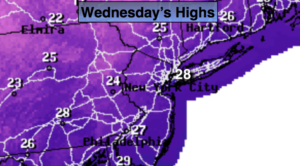
Today:
Partly sunny, breezy and very cold. Scattered afternoon flurries possible. Highs in the upper 20s. Northwest winds at 10-20mph with higher gusts. Wind chills near 20º.
Tonight:
Mostly clear and frigid. Lows in the upper teens in urban areas, the single digits and teens inland. Northwest winds at 8-15mph.
Thursday:
Partly sunny, cold. Scattered afternoon flurries possible. Highs around freezing.
Friday:
Mostly cloudy, not as cold. Late day snow showers are possible. Highs in the mid 30s.
Saturday:
Partly sunny, seasonal. Highs in the mid 40s.
Sunday:
Rain likely. Mild. Highs around 50º.