Synopsis:
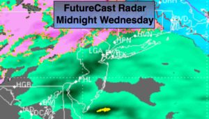
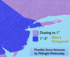
On and off snow will turn to a mix and then rain this evening and tonight. Before the changeover there’s the potential for dusting (out East) to a light accumulation (South & West) depending on your location. The possible accumulation map is above. These amounts have come down a tad while looking at the latest radar trends. Please use caution on untreated surfaces as it will be treacherous.
A mix to rain is expected this evening and tonight as the low moves off the New England coast. Freezing rain is possible well inland with icing being a concern. The rain will end before sunrise Thursday. Highs on Thursday will spike into the 50s as clouds give way to sun.
More seasonal temperatures are expected Friday and Saturday. It’ll be mainly sunny.
Another low will move toward the region Saturday night and Sunday morning with rain likely.
Keep it here for a no nonsense, no hype forecast.
Tonight:
Mix to rain. Freezing rain well inland. Lows in the mid to upper 30s in the City, near freezing well inland. Southeast to East winds at 5-10mph.
Thursday:
Early clouds, otherwise becoming partly sunny. Mild. Highs in the mid 50s.
Friday:
Mostly sunny. Highs in the mid 40s.
Saturday:
Sun to clouds. Highs in the mid 40s.
Sunday:
Morning rain, followed by some sun. Highs in the mid 50s.
Monday:
Partly Sunny. Highs in the mid 40s.