Synopsis:
It’ll be windy through early evening with spotty snow showers as a disturbance moves through the area. Skies will clear out tonight. There will be a re-freeze of water and slush. Use caution on untreated surfaces.
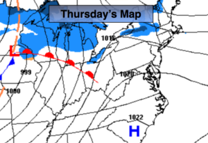
Thursday will be mainly sunny with mild readings as high pressure moves off the Southeast coast.
A cool front will approach on Friday with scattered showers, otherwise a mix of sun and clouds is expected. It’ll be mild.
Two weak areas of low pressure will move toward and off the East coast this weekend. System #1 looks to slide to our South Saturday sparing the area of any light snow. System #2 has a low potential of delivering a bit of light snow Sunday night. Both weekend days will feature a mix of sun and clouds and seasonal readings.
Keep it here for a no nonsense, no hype forecast.
Rest of Today into Tonight:
Spotty snow showers and windy through early evening, otherwise mostly clear and cold. Lows in the 20s throughout. West winds at 10-20mph and diminishing.
Thursday:
Mostly sunny, mild. Highs in the mid 40s. West to Southwest winds at 10-15mph.
Friday:
Sun and clouds with spotty showers. Mild. Highs in the mid 50s.
Saturday:
Sun and clouds. Highs around 40º.
Sunday:
Sun to clouds. Slight chance of a period of light snow during the evening and at night. Highs in the upper 30s.
Monday:
Partly sunny. Highs in the upper 30s.