Synopsis:
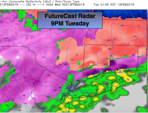
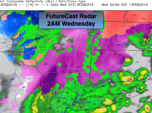
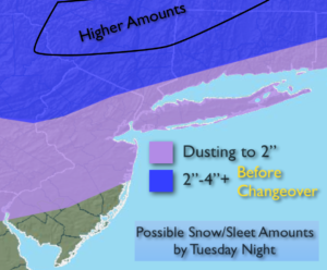
A storm over the Great Lakes and a secondary storm developing over the area tonight will cause a mild flow from the South aloft causing the snow (well North), sleet and freezing rain to go over to rain in most areas. The exception will be extreme Northwestern NJ and interior NY state. The first two maps above show the progression of the purple area (freezing rain) at 9pm to the second map at 2am. You can see how the area of green-rain works North. Where temperatures remain below freezing a prolonged period of sleet and freezing rain will occur. Treacherous travel is expected on untreated surfaces. Potential snow/sleet amounts are above.
The rain or freezing rain depending on location will taper off before sunrise tomorrow.
Tranquil and mild conditions are expected Wednesday and Thursday with high pressure sitting over the Southeast.
The forecast gets less confident heading into the weekend. There will be two weak storms on the map. The potential for a brush of light snow is possible with both systems. Please check back to JMW as more computer guidance comes in .
Stay tuned.
Rest of Today into Tonight:
Snow, sleet, freezing rain and rain. Most areas will go over to rain with the exception of Northwestern regions. Treacherous travel to be expected on untreated surfaces and where temperatures remain near freezing. Lows in the 30s throughout. Northeast winds becoming West at 10-20mph.
Wednesday:
Partly sunny and windy. Highs in the lower to mid 40s. West winds at 15-30mph.
Thursday:
Mostly sunny, mild. Highs in the mid 40s.
Friday:
Partly sunny. Mild. Highs in the lower 50s.
Saturday:
Mostly cloudy. Slight chance of a period of light snow. Highs around 40º.
Sunday:
Mostly cloudy. Slight chance of a period of light snow. Highs in the 30s.