Synopsis:
Our Spring fling is over, after temperatures soared into the mid 60s in many locations yesterday. High today will be only in the 40s.
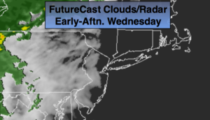
Two rounds of rain are on the way: one round will work in for the PM commute today and continue into early Thursday morning. This is a result of an area of low pressure moving along a stationary front just to our South. Round two will be with an approaching cold front on Friday.
A return to more seasonal February conditions are expected this weekend as high pressure works in from Canada. Highs will be below the seasonal average high of 40º under a mix of sun and clouds.
Looking ahead there will be a complex area of low pressure developing early to mid week next week. Arctic air will be to our North. How this all plays out remains to be seen. Be aware there is a potential of Wintry precipitation next week.
You know where to find a no hype, no nonsense forecast.
Stay tuned.
Today:
Sun to clouds. Rain will move in by evening. Highs in the lower to mid 40s. North to Northeast winds at 5-10mph.
Tonight:
Rain. Lows in the 30s throughout. East to Northeast winds at 5-10mph.
Thursday:
Early morning rain, otherwise remaining mostly cloudy. The majority of the day will be dry. Highs in the mid 40s.
Friday:
Mostly cloudy. Balmy. Scattered morning showers. Highs in the mid to upper 50s.
Saturday:
Mostly sunny and colder. Highs in the mid 30s.
Sunday:
Mostly sunny. Highs in the mid to upper 30s.