Synopsis:
Today will be dry and chilly as high pressure over Eastern Canada supplies the region with seasonal readings under a mix of sun and clouds.
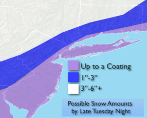
A polar vortex (frigid rotating airmass) will swing out of Canada and move to the Great Lakes tomorrow and Wednesday. This airmass will be bitterly cold. The upper level winds will be traveling at a very high speed and a good bit of energy will swing through the area. Rain and snow showers are in the forecast for Tuesday afternoon. A period of snow is possible Tuesday night with the developing low pressure and a front moving through the region. Accumulations are possible, mainly to the North and West of the City where a few to several inches may fall-possible snow amounts graphic is above. The coast won’t see much in the way of accumulation. The storm won’t get it’s act together until it’s well to the North and East of the area.
A bitter blast will once again grip the area on Wednesday and Thursday as the polar vortex pushes it’s Arctic grip on the tri-state area. Temperatures maybe as cold or even a tad colder the MLK’s frigid readings.
You know where to find a no hype, no nonsense forecast.
Stay tuned.
Today:
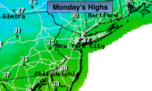
Partly sunny and seasonal. Highs in the mid 30s. North to Northeast winds at 5mph.
Tonight:
Mostly clear early, becoming mostly cloudy late. Lows around 30º in the City, the 20s and teens elsewhere. Northeast to East winds at 5mph.
Tuesday:
Mostly cloudy. Rain or snow showers are possible during the afternoon. Highs around 40º.
Wednesday:
Partly sunny, wind and very cold. Scattered midday snow squall are possible. Highs in the 20s with readings plummeting during the day, reaching the teens by dark.
Thursday:
Mostly sunny and frigid. Highs 8º to 14º.
Friday:
Mostly sunny and very cold. Highs in the mid 20s.