Synopsis:
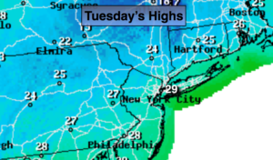
It’ll be a slow recovery today with plenty of sunshine as highs reach upper 20s. The Arctic high pressure will slide off the coast later this afternoon releasing it’s bitter blast on the region.
A January thaw is expected for midweek. A Southerly wind will bring up milder air, but we’ll have to pay a bit of a price with wet weather moving in. Any sunshine on Wednesday will give way to thinking clouds. A front will move our way from the West increasing the threat of showers later in the day. A low will develop along that front over the Virginia Piedmont Wednesday night and Thursday. This will cause the rain to become steadier and heavier. Highs both days will be well into the 40s to near 50º on Thursday.
It’ll turn more seasonal on Friday as we dry out. The weekend will be cold under a mix of sun and clouds. There is a signal that a low will try to develop off the Southeast coast for Sunday. At this time it looks to go offshore.
You know where to find a no hype, no nonsense forecast.
Stay tuned.
Today:
Sunny and cold. Highs in the upper 20s. Northwest winds diminishing to 5-10mph.
Tonight:
Partly cloudy. Not as cold as recent nights. Lows in the upper 20s in the City, the teens inland. Southwest wind at 5mph.
Wednesday:
Mostly cloudy and much milder. Chance of afternoon showers. Highs in the mid 40s.
Thursday:
Rain. Mild. Highs near 50º.
Friday:
Partly sunny and seasonal. Highs in the mid 30s.
Saturday:
Partly sunny and cold. Highs around 30º.