Synopsis:
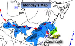
Weak low pressure that brought a light coating of snow well inland this morning will move offshore. Spotty rain and or snow showers will linger through the morning hours, otherwise, skies will become partly sunny. Temperatures will be tolerable, reaching the mid 40s.
Christmas Day will feature sunshine and seasonal readings. No white Christmas this time around. High pressure will dominate through Thursday with tranquil conditions.
Looking down the pike for the rest of the Holiday week, the next chance of precipitation comes along Thursday night into Friday. Once again it looks too warm for snow-rain is expected at this time as the storm will ride to our West-a warm scenario.
You know where to find a no hype, no nonsense forecast.
Stay tuned.
Christmas Eve:
Early morning scattered rain or snow showers, otherwise clouds giving way to partly sunny skies. Highs in the lower to mid 40s. Winds becoming Northwest and increasing to 10-20mph by afternoon.
Tonight:
Mostly clear. Lows around freezing in the City, the 20s inland. West to Northwest winds at 8-12mph.
Christmas Day:
Sunny and seasonal. Highs in the lower 40s.
Wednesday:
Sunny. Highs in the lower 40s.
Thursday:
Mostly sunny. Highs around 40.
Friday:
Rain likely. Mild. Highs in the lower to mid 50s.
Keep it here for a no nonsense, no hype forecast.