Synopsis:
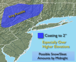
Low pressure off the NJ coast Sunday evening will move Southeast of Eastern Long Island tonight. Rain will continue this evening for most areas. Well inland, just enough cold air will be present for a mix of rain, wet snow, freezing rain and or sleet. Minor accumulations of snow and sleet are possible, especially over the higher elevations (map above).
The precipitation will end overnight. Icy conditions are possible in areas that hover around freezing through the Monday morning commute.
We’ll get a chance to dry out the next several days. High pressure over the midwest will head toward our area, at the same time the storm that gave us the rain will move into the Canadian Maritimes. This will cause a gusty wind both Monday and Tuesday. It’ll be bright with temperatures just above seasonal levels Monday. A chill will be in the air Midweek.
The next weather maker moves in on Thursday night and Friday at this time the storm looks to pass to our West. This is a mild scenario meaning rain and not snow. Something snow lovers don’t want to hear.
You know where to find a no hype, no nonsense forecast.
Stay tuned.
Tonight:
Periods of rain this evening. Wet snow or a mix inland. Precipitation will end from West to East within a few hours either side of Midnight. Lows in the 30s throughout. Winds becoming Northwest at 10-15mph.
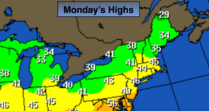
Monday:
Partly sunny, becoming windy during the afternoon. Seasonal. Highs in the mid 40s. Northwest winds increasing to 15-30mph.
Tuesday:
Partly sunny, breezy and colder. Highs in the upper 30s.
Wednesday:
Sunny. Cold. Highs in around 40º.
Thursday:
Sun to clouds, milder Highs in the upper 40s.
Friday:
Periods of rain. Balmy. Highs in the mid to upper 50s.
Keep it here for a no nonsense, no hype forecast.