Synopsis:
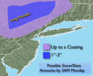
Low pressure will develop over the Delmarva Peninsula on Sunday morning and then move and off Eastern Long Island by Sunday night. Rain will develop late tonight and continue on and off on Sunday at the coast. The potential is now there for it to be marginally cold enough for a mix of wet snow, sleet and freezing rain well inland during the day Sunday. If the conditions are just right an accumulation of snow and sleet is possible inland (especially over the higher elevations) possible accumulation map above. As of this writing, I’m calling for rain along the coast and in the City and nearby suburbs.
Looking down the pike, a cool down is expected by Tuesday, no major storms are expected through Thursday. The next weather maker moves in on Thursday night and Friday at this time it looks to pass to our West. This is a mild scenario meaning rain and not snow. Still several days to watch it pan out.
You know where to find a no hype, no nonsense forecast.
Stay tuned.
Tonight:
Rain redeveloping. Colder. Lows in the 30s throughout. Northeast winds increasing to 10-20mph.
Sunday:
Periods of rain. Wet snow,sleet and freezing rain possible inland. Highs around 40º in the City, the 30s inland. Northeast winds at 15-25mph.
Monday:
Partly sunny, becoming windy. Seasonal. Highs in the mid 40s.
Tuesday:
Partly sunny. Colder. Highs in the mid 30s.
Wednesday:
Sunny. Cold. Highs in around 40º.
Thursday:
Sun to clouds, milder Highs in the upper 40s.
Keep it here for a no nonsense, no hype forecast.