Synopsis:
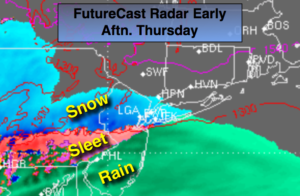
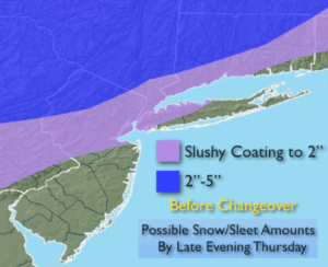
A storm will affect the area from midday into Friday morning. The models develop a low over the Southeast and move it up the coast. High pressure will funnel in cold air from New England today into early evening. At the same time, a decent amount of precipitation will working in from the South with the advancing storm. A mix of wet snow, sleet and rain will develop midday and continue into the night. The precipitation will come down heavy at times into the evening. A Flood Watch is in effect for this afternoon and evening for Monmouth and Ocean counties. One to two inches of rain is possible. The mix will go over to rain later in the afternoon and evening along Northern coastal areas and in the City. The potential is there for an accumulation of snow and sleet before the changeover to rain later this afternoon and evening. A slushy coating is possible in and around the NYC vicinity. The highest amounts will be over far Northwestern NJ, the Poconos and Upstate NY where the duration of snow and sleet will be the longest. The map above is the potential amounts. Freezing rain is possible overnight over the far Northwestern suburbs with icing likely.
It’ll become windy overnight as the storm nears. A Wind advisory is in effect for Monmouth and Ocean counties for Northeast winds gusting to 45mph.
As the upper low moves over the area early Friday morning a quick shot of rain and or wet snow is possible. The the sun will return later in the morning as the storm moves up the coast.
The weekend will be chilly with a decent amount of sunshine.
You know where to find a no hype, no nonsense forecast.
Stay tuned.
Today:
Thickening clouds-wet snow, sleet and rain will move in by late morning into the midday hours. The precipitation could come down heavy at times. Most areas North of a Trenton-NYC-Coastal Connnecticut line will see frozen precipitation at the onset. To the South and East rain will fall (1st map above). Cold. Highs only in the 30s. Northeast winds at 8-12mph increasing to 15-25mph toward evening.
Tonight:
Frozen precipitation will go over to rain with the exception of far Northwestern regions where freezing rain is likely. Lows in the 30s throughout. Northeast winds at 15-30mp with gusts to 45mph at the coast.
Friday:
A quick shot of early morning rain or wet snow. otherwise the sun will make an appearance. Highs in the mid 40s.
Saturday:
Mostly sunny and chilly. Highs in the upper 40s.
Sunday:
Mostly sunny and chilly. Highs in the mid 40s.
Monday:
A mix of sun and clouds. Flurries are possible. Highs in the lower 40s.
Keep it here for a no nonsense, no hype forecast.