Synopsis:
Showers and storms will continue to move East of the City and through central and Southern NJ by late afternoon. The sun should make an appearance in most areas before evening (maybe excluding far Eastern sections). The wet humid weather was a result of the remnants of Florence.
Skies will clear tonight and humidity levels will drop as the remains of Florence move out to sea.
High pressure will move in tomorrow. The humidity will be much lower with plenty of sunshine. Fine September weather will be with us through Friday.
The first weekend of Autumn will feel like the season under partly sunny skies.
You know where to find a no hype, no nonsense forecast.
Stay tuned.
Tonight:
Any showers or storms ending at the coast by early evening. Becoming mostly clear with lowering humidity. Lows in the upper 60s in the City, near 60º inland. North wind at 5mph.
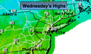
Wednesday:
Mostly sunny. Much less humid. Highs around 80º. North wind at 8-12mph.
Thursday:
Mostly sunny, cooler. Highs in the mid 70s.
Friday:
Partly sunny. Much warmer. Highs in the lower to mid 80s.
Saturday:
Partly sunny. Highs in the mid 70s.
Sunday:
Partly sunny, cooler. Highs in the lower 70s.
Keep it here for a no nonsense, no hype forecast.