Synopsis:
A front will move off the coast today. Clouds will give way to some sunshine. It’ll be warm, but you’ll notice a drop in the humidity by afternoon. An isolated afternoon storm is possible.
High pressure will move in from the Midwest tomorrow and stick around through the weekend. Sunny skies and low humidity is expected the next several days. Temperatures will be near the average high of 82º. This will be a nice stretch for late August. Overnight readings will have that Fall feel with temperatures in the 50s inland.
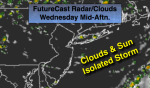
Today:
Morning clouds will give way to some sun. Warm and becoming less humid during the afternoon. An isolated PM storm is possible. Most areas will remain dry. Highs in the mid 80s. West to Northwest winds at 8-12mph.
Tonight:
Clear and much less humid. Comfortable sleeping weather. Lows in the mid to upper 60s in the City, the upper 50s inland. Northwest winds at 5-10mph.
Thursday:
Mostly sunny and breezy. Low humidity. Highs in the upper 70s to around 80º.
Friday:
Sunny. Highs around 80º.
Saturday:
Sunny. Highs in the lower 80s.
Sunday:
Mostly sunny. Highs in the mid 80s.
Keep it here for a no nonsense, no hype forecast.