Synopsis:
A strong Southerly flow around high pressure near Bermuda will cause the humidity to be sky high until further notice. A weak trough over the Appalachians will result in scattered showers and storms each day through Saturday. Locally downpours are possible. There will be times of hazy sun. It will not be a washout.
By Sunday, a wind off the land will result in mainly sunny skies without the threat of spotty storms. It’ll be hot.
Stay tuned.
Today:
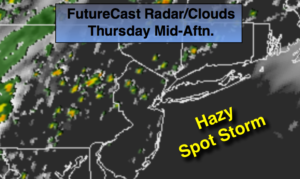
Hazy and humid. Spotty showers and storms. Highs in the mid to upper 80s. Southwest to South wind at 10-15mph.
Tonight:
Isolated storms early, most areas will remain dry otherwise, mostly cloudy. Muggy and warm. Lows in the mid 70s in the City, the lower 70s inland. Southwest winds 5mph.
Friday:
Hazy and humid. Scattered showers and storms. Highs in the mid 80s.
Saturday:
Hazy and humid. Scattered showers and storms. Highs in the mid 80s.
Sunday:
Hazy, hot and humid. Highs near 90º.
Monday:
Hazy, hot and humid. Highs near 90º.
To repeat the next 3 days will not be a washout and much of the time will be dry.
Keep it here for a no nonsense, no hype forecast.