Synopsis:
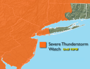
***A Severe Thunderstorm Watch is in effect until 10PM for the tri-state area, excluding Suffolk County Long Island*** Severe storms contain winds in excess of 58mph and or large hail. A watch means just that-we’ll watch the situation for the potential of severe weather. Keep an eye to the sky for threatening weather conditions.
Hazy, very warm and humid conditions are expected into this evening. A front will be approaching the region. Scattered storms are likely later in the afternoon and evening. Frequent cloud to cloud lightening and torrential rain is possible in any of the storms.
The storms will diminish by late evening. Skies will be mostly cloudy. It’ll remain muggy.
The weekend should be mainly dry as high pressure from the West begins to take hold under a mix of sun and clouds. It’ll be much less humid by Sunday with seasonal readings.
Looking ahead, another Bermuda high will begin to setup shop mid to late week with heat and humidity returning.
Stay tuned.
Tonight:
Scattered strong to severe storms during the evening, otherwise, mostly cloudy. Lows in the lower 70s in the City, the 60s inland. Southwest winds under 5mph.
Saturday:
Clouds and sun. An isolated afternoon storm is possible. Most areas will remain dry. Highs in the mid 80s. South wind at 5-10mph.
Sunday:
Sunny. Low humidity. Highs in the mid 80s.
Monday:
Mostly sunny. Highs in the mid 80s.
Tuesday:
Sun and clouds. Humid. Scattered showers are possible. Highs in the lower 80s.
Wednesday:
Mostly cloudy. Humid. Scattered showers and storms. Highs in the mid 80s.
Keep it here for a no nonsense, no hype forecast.