Synopsis:
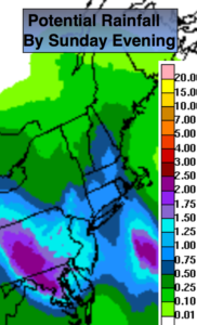
Areas of steady and heavy rain is expected overnight as a storm moves North into Eastern PA. The heaviest rain will fall South and West of the City. A Flash Flood Watch has been posted for Ocean and Mercer counties. Generally one to two inches of rain is expected with lighter amounts over Long Island. It’ll be windy at the coast with Easterly winds gusting up to 45mph at times. A Wind Advisory has been issued for NYC vicinity and the NJ coast through late tonight. The steady rain will taper off early Sunday morning. As the low pulls away Sunday some sun is expected. Scattered showers and storms are possible during the afternoon. It will not be a washout.
An upper level low will move into the Appalachians Sunday through the beginning of the week. At the same time, a strong high pressure system will be over the Western Atlantic. This will result in a deep Southerly flow of tropical air. Scattered showers and storms are possible. Some of the rain maybe heavy. It won’t be a washout and a good part of the time will be dry. It’ll be warm and very humid.
Stay tuned.
Tonight:
Periods of rain and a few thunderstorms. Locally heavy rain. Lows in the 60s throughout. East wind 10-20mph with gusts to 45mph at the coast.
Sunday:
Scattered areas of showers and storms, otherwise sun and clouds. Warm and humid. It will not be a washout. Highs mid 80s. Southeast winds at 10-20mph.
Monday:
Hazy, warm and humid with scattered storms. Highs in the lower 80s.
Tuesday:
Hazy, warm and humid with scattered storms. Highs in the mid 80s.
Wednesday:
Hazy, warm and humid with scattered storms. Highs in the mid 80s.
Thursday:
Hazy, warm and humid with scattered storms. Highs in the mid 80s.
Keep it here for a no nonsense, no hype forecast.