Synopsis:
High pressure will move in for the rest of the week resulting in typical July readings and low humidity. The humidity will once again increase this weekend. At this time both days should be rain-free and very warm.
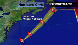
Hurricane Chris is a category 2 storm with winds of 105mph. The hurricane will continue to race off to the Northeast and move away from the East coast. Rough surf and dangerous rip currents will be the main concern for our area during the upcoming week. Please swim by guarded beaches. If you get caught in a rip current-remain calm. Swim parallel to shore until you are freed from the rip current then swim back to the beach.
Stay tuned.
Today:
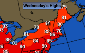
Mostly sunny, not as hot and less humid. Highs in the mid 80s. North winds at 5-10mph.
Tonight:
Partly cloudy. Lows in the upper 60s in the City, the 50s inland. North wind less than 5mph.
Thursday:
Sunny. Highs in the mid 80s.
Friday:
Sunny. Highs in the mid 80s.
Saturday:
Partly sunny, more humid. Highs in the mid 80s.
Sunday:
Partly sunny, very warm and humid. Highs in the upper 80s.
Keep it here for a no nonsense, no hype forecast.