Synopsis:
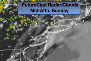
Clouds and patchy morning fog will give way to some sunshine today. It’ll be warmer and more humid. A cool front will approach later in the day with spotty showers and thunderstorms. The majority of the time will be dry. Temperatures will be near seasonal average-the lower 80s.
Scattered showers and storms will end by early tonight as the front passes off the coast.
The beginning of the workweek looks a winner with plenty of sunshine and warm temperatures as high pressure moves in. The humidity will be at low levels.
A weak disturbance may spark scattered showers and storms on Thursday. This feature will usher in the heat by the end of the week.
Stay tuned.
Today:
Morning clouds and patchy fog will give way to some sun. Warmer and more humid. Spotty afternoon showers and thunderstorms. Highs in the lower to mid 80s. Southwest winds at 5-10mph.
Tonight:
Early scattered showers and storms, otherwise, partly cloudy. Lows in the 60s throughout. Winds becoming Northwest at 5-10mph.
Monday:
Mostly sunny and much less humid. Highs in the lower 80s.
Tuesday:
Sunny. Highs around 80º.
Wednesday:
Partly sunny. Warm. Highs in the mid 80s.
Thursday:
Clouds and sun. Scattered showers and storms. Humid Highs in the mid to upper 80s.
Keep it here for a no nonsense, no hype forecast.