Synopsis:
This evening will be hot and humid with isolated storms. Most areas will be dry. By late evening and tonight scattered thunderstorms may affect more of the region. Some of the storms may be strong as a cool front approaches.
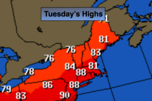
The front will be a humidity buster. Tuesday will still be hot, but the humidity will be much lower. Mostly sunny skies are expected.
An end to the early season heat will arrive by Wednesday with much more comfortable conditions.
A weak disturbance moving in from the West will cause showers Wednesday late evening and into the night.
Summer arrives on Thursday. The change of season promises not to disappoint as high pressure works in. The high will provide seasonal temperatures and pleasant conditions Friday and into Saturday.
Stay tuned.
Tonight:
Mostly cloudy with spotty thunderstorms. Warm and humid. Lows in the 70s throughout. Southwest to West winds at 8-12mph.
Tuesday:
Mostly sunny. Hot, but much less humid. Highs in the 80s to around 90º. Northwest winds at 10-15mph.
Wednesday:
A mix of sun and clouds. Highs in the lower to mid 80s.
Thursday:
Mostly sunny and warm. Highs in the mid 80s.
Friday:
Sunny and warm. Highs in the lower 80s.
Saturday:
Partly sunny and seasonal. Highs around 80º.
Keep it here for a no nonsense, no hype forecast.