Synopsis:
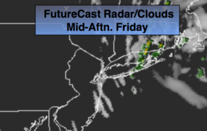
It’ll be a fine finish to the workweek. Temperatures will be just below the average high for the date which is near 80º. An upper level disturbance over New England will affect Eastern section of the tri-state area this afternoon with patchy clouds. Spotty afternoon showers are possible over Eastern Long Island and Connecticut. Partly sunny skies are expected elsewhere.
The weekend will be Summer-like with plenty of sunshine. Father’s Day will be mostly sunny with highs well into the 80s with higher humidity as high pressure builds off the East coast.
Monday will be sizzling with readings into the 90s as a hot bubble of air moves in from the Midwest.
A cool front will approach later Tuesday bringing an end to the early season heat.
Stay tuned.
Today:
Partly sunny. Becoming mostly cloudy to the East with spotty showers possible this afternoon. Highs in the mid 70s. Northwest winds at 8-12mph.
Tonight:
Becoming mostly clear. Lows in the lower 60s in the City, the 50s inland. Light and variable winds.
Saturday:
Sunny. Warm. Highs in the mid 80s.
Sunday:
Mostly sunny, very warm and humid. Highs in the mid to upper 80s.
Monday:
Hazy, hot and humid. Highs in the mid 90s.
Tuesday:
Hazy, hot and humid. Spotty afternoon storms. Highs around 90º.
Keep it here for a no nonsense, no hype forecast.