Synopsis:
A winner will be with today as high pressure moves in.
The weekend right now looks to start warm and more humid. Showers are likely in the morning on Saturday with a warm front moving through. The front will most likely stall around the NYC vicinity. The sun should return (especially South of the City) and then the threat is there for late afternoon storms. Highs on Saturday will depend on your location. North of the warm front readings will be held to the 60s. To the South of the front it’ll be warm and humid with highs in the 70s and lower 80s.
On Mother’s Day a front will be close to the region. If the system stays overhead showers are likely. There is a chance that the front will slip just to our South leaving Mother’s Day with some sunshine. At this time I’ve included the threat of showers. Hopefully, this forecast will change.
Stay tuned.
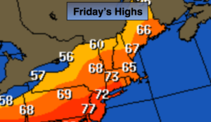
Today:
Mostly sunny. Highs in the lower 70s. Northwest wind at 5-10mph.
Tonight:
Partly cloudy early, then increasing clouds with showers and storms after midnight. Lows in the mid 50s in the City, the upper 40s inland. Light winds.
Saturday:
Morning showers, then the sun will make an appearance from NYC and to the South. The clouds maybe stubborn to burn off North and East. A spotty late day storm is possible. It will mot be a washout. Highs in the 60s from the NYC vicinity and to the North and East to the 70s & 80s over Central and Southern NJ.
Mother’s Day:
Mostly cloudy with the threat of showers. Highs in the mid 60s.
Monday:
Mostly cloudy. Highs in the mid 70s.
Tuesday:
Partly sunny. Warm. Highs in the lower 80s.
Keep it here for a no nonsense, no hype forecast.