Synopsis:
Some of the best weather of the year will continue as high pressure hold along the East coast. Temperatures will be just above seasonal average under mainly sunny skies today. The average high temperature for this time of the year is near 70º.
A weak cool front will approach later Thursday with sun giving way to clouds. A few late afternoon showers are possible.
Another winner will be with us on Friday as high pressure once again moves in.
The weekend right now looks to start warm and more humid with a late day storm possible on Saturday. On Mother’s Day a front will be close to the region. If the system stays overhead showers are likely. There is a chance that the front will slip just to our South leaving Mother’s Day with some sunshine. At this time I’ve included the threat of showers. Hopefully, this forecast will change.
Stay tuned.
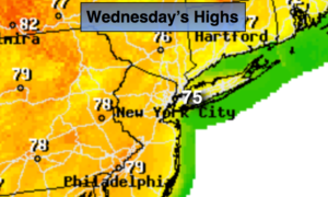
Today:
Sunny. Highs in the mid 70s. East to Southeast winds at 5-10mph.
Tonight:
Clear. Lows in the mid 50s in the City, the 40s inland. Light Southeast wind less than 5mph.
Thursday:
Sun to clouds. Late day showers are possible. Highs in the lower to mid 70s.
Friday:
Mostly sunny. Highs in the lower 70s.
Saturday:
Partly sunny. Warmer and more humid. A spotty late day storm is possible. Highs in the 70s to around 80º.
Mother’s Day:
Mostly cloudy with the threat of showers. Highs in the lower 70s.
Keep it here for a no nonsense, no hype forecast.