Synopsis:
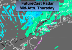
A rapidly moving low pressure will move off the New England coast later this afternoon and move out to sea. There will be two batches of showers. One early this morning with the low over the region; the other this afternoon with the passage of the cold front. It will feel more like early March than mid April. In fact, don’t be surprised if a few flakes fly mainly North of the City today.
The sun will once again return Friday but it will be windy and chilly. The weekend looks mainly sunny and cool and high pressure works in.
It looks like below average temperatures will continue for some time as the Northern branch of the jet stream remains close to our latitude. We’ll also be watching a storm off the Southeast coast. Yep, this Spring is tough to take.
Stay tuned.
Today:
Mostly cloudy. Rain early this morning, then remain mainly cloudy with scattered showers this afternoon. Highs in the 40s to around 50º. Becoming breezy later in the afternoon. Northeast to Northwest winds increasing to 10-20mph later in the day.
Tonight:
Spotty early evening showers, otherwise, becoming partly cloudy. Cold. Lows in the 30s throughout. Windy. Northwest winds at 15-30mph.
Friday:
Partly sunny. Windy. Highs around 50º.
Saturday:
Mostly sunny. Highs in the mid 50s.
Sunday:
Sunny. Highs in the upper 50s.
Monday:
Mostly sunny. Highs around 60º.
Keep it here for a no nonsense, no hype forecast.