Synopsis:
Upper level energy will work through this evening behind the storm that affected the area on Monday resulting in spotty showers and breezy conditions. Later tonight the winds wills subside and skies will become partly cloudy.
The sun will return Wednesday as the area is in between systems. A rapidly moving low pressure will move through on Thursday with another round of spotty showers. The sun will once again return Friday but it will be windy and chilly. The weekend looks mainly sunny and cool and high pressure works in.
It looks like below average temperatures will continue for some time as the Northern branch of the jet stream remains close to our latitude. Yep, this Spring is tough to take.
Stay tuned.
Tonight:
An isolated evening shower, otherwise, becoming partly cloudy. Lows in the upper 30s in the City, near freezing inland. West winds at 10-15mph with gusts to 20mph and diminishing.
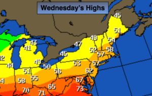
Wednesday:
Mostly sunny. Highs in mid to upper 50s. West winds at 10-15mph.
Thursday:
Mostly cloudy. Chance of showers. Highs in lower to mid 50s.
Friday:
Partly sunny. Windy. Highs around 50º.
Saturday:
Mostly sunny. Highs in the mid 50s.
Sunday:
Mostly sunny. Highs in the upper 50s.
Keep it here for a no nonsense, no hype forecast.