Synopsis:
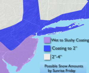
A front with a weak developing area of low pressure will move to the Eastern Seaboard tonight. Scattered showers will likely develop this evening. A steadier period of rain will develop toward Midnight. As the colder air works in the rain will turn to a quick period of snow overnight and end early Friday Morning give or take a few hours on either side of sunrise. The possible amounts are above. Please use extreme caution as temperatures will plummet below freezing before the morning commute. It will be hazardous on untreated surfaces. The sun will return quickly during the morning and temperatures will go nowhere-staying in the 20s to around freezing. Winds will add a bit. A cold day indeed.
It will be cold to start the weekend with high pressure overhead on Saturday. An area of moisture over the Southeast with an area of low pressure looks very close to the trim-state area on Super Bowl Sunday and at night. Snow and rain showers are possible on Sunday. The one ingredient that this scenario is lacking is cold high pressure to our North. For this reason, the snow will most likely go over to a mix or rain for many areas. All all snow event is highly unlikely at the point at the coast but inland some accumulation is likely. This is not etched in stone. Still a few days to watch this unfold.
Stay tuned.
Tonight:
Rain will turn over to a period of snow or snow showers for a few hours before sunrise. Lows in the upper 20s in the City, the lower to mid 20’s inland. South to Northwest winds increasing to 10-20mph by morning.
Friday:
Early morning East, otherwise mostly sunny. Breezy. Highs in the upper 20s. Northwest winds at 15-30mph.
Saturday:
Sunny and cold. Highs around freezing.
Sunday:
Mostly cloudy with a chance of rain and snow showers. Highs near 40º.
Monday:
Partly sunny. Highs in the upper 30s.
Tuesday:
Partly sunny. Highs in the upper 30s.
Keep it here for a no nonsense, no hype forecast.