Synopsis:
A distributive snowstorm will affect areas closest to the coast on Thursday. Blizzard Warnings have been issued for Monmouth, Ocean and Suffolk counties with Winter Storm Warnings and Advisories elsewhere.
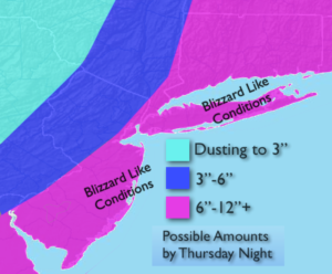
A rapidly intensifying storm will develop off the Southeast coast and move North tonight and Thursday. The latest computer models have the storm over or just to the East of a favorable track for significant snow. The storm’s barometric pressure is incredibly low and usually found only in hurricanes. Some of the computer models have a good amount of snow for a majority of the area, while other have added “some” to their snow amounts. A shift more toward the West would mean a greater potential for higher amounts for all areas. A shift to the East, lighter amounts. At this time, I think a Westward shift will happen. For this reason, I have upped the possible snow amounts (map above). The highest snow totals will be at the coast with lighter amounts farther inland.
Blizzard conditions are likely along the coast with near whiteout conditions. Winds will gust between 30-60mph with the higher gusts at the coast.
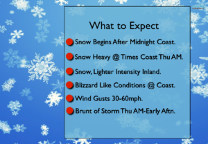
The snow begins tonight and continues Thursday. The snow will taper off from West to East during the day.
It will be “The Storm of Miles”. The difference of a few miles could mean the difference between a bit of snow and big snow.
The coldest air of the season will usher in Friday. Highs will struggle to get to 10º. Not fun times.
Stay tuned.
Tonight:
Increasing and thickening clouds. Light snow developing around Midnight from the coast than farther inland. Lows in the lower 20s in the City, near 5º to 15º inland. Winds becoming North to Northeast and increasing to 15-25mph late.
Thursday:
Snow. Heavy at times along the coast. Very windy. The snow will taper off during the afternoon from West to East. Highs in the mid 20s. Northwest winds at 20-40mph with gusts to 60mph at the coast.
Friday:
Partly sunny, windy and bitterly cold. Highs 8º to 15º above. Wind chills well below zero.
Saturday:
Partly sunny and bitterly cold. Highs within a few degrees of 10º.
Sunday:
Mostly sunny and cold. Highs in the mid 20s.
Monday:
Mostly cloudy with rain or snow. Highs in the mid 30s.
Keep it here for a no nonsense, no hype forecast.