Synopsis:
The below freezing readings will continue until further notice. The last time the temperature was above freezing was Christmas Day.
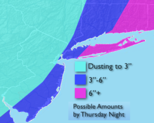
Now on to the snow potential. A rapidly intensifying storm will develop off the Florida coast and move North Wednesday night and Thursday. The latest computer models have the storm over or just to the East of a favorable track for significant snow. The storm’s barometric pressure is incredibly low and usually found only in hurricanes. Some of the computer models have a good amount of snow for a majority of the area, while other models just have a glancing blow. A shift more toward the West would mean a greater potential of accumulating snow for all areas. A shift to the East, little to no snow. I will go in the middle of the road with snow amounts. Above is the first stab at potential snow amounts. The highest snow totals will be at the coast with lighter amounts farther inland. This will no doubt change.
The snow begins Wednesday night and continues Thursday. It will be “The Storm of Miles”. The difference of a few miles could mean the difference between a bit of snow and big snow.
Whatever the outcome with the ocean storm, the coldest air of the season will usher in Friday. Highs will struggle to get to 10º.
Stay tuned.
Tonight:
Clear and frigid. Lows in the mid teens in the City, near 0º to 10º inland. West winds at 5-10mph.
Wednesday:
Partly sunny and cold Highs in the upper 20s to around 30º. West to Southeast winds at 5mph.
Thursday:
Mostly cloudy with a potential of snow, especially at the coast. Highs in the mid 20s.
Friday:
Partly sunny, windy and bitterly cold. Highs 8º to 12º above. Wind chills well below zero.
Saturday:
Partly sunny and bitterly cold. Highs within a few degrees of 10º.
Sunday:
Mostly sunny and cold. Highs in the mid 20s.
Keep it here for a no nonsense, no hype forecast.