Synopsis:
A bitter blast will be with us through the end of the year as the gates are open for Arctic air to spill into the nation as strong high pressure moves in from Canada. Readings will be below freezing through the weekend with overnight lows in the single digits and teens.
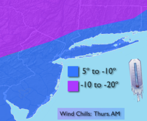
Wind chills will be dangerously today. Life threatening conditions are possible if proper winter attire is not worn. The map above depicts just how cold it’ll feel.
The only chance of seeing any flakes the next five days will be on Saturday. A low will form well off the coast. This system in conjunction with a disturbance in the upper atmosphere will cause a few snow showers or a period of light snow. This will not be a big deal.
As stated, the bitter cold will stick around through New Year’s Day. At least it’ll be tranquil.
Stay tuned.
Today:
Mostly sunny. Very cold. Highs in the lower 20s. Northwest winds at 15-25mph. Wind chills in the single digits by afternoon.
Tonight:
Partly cloudy. Frigid. Lows in the lower teens in the City, the single digits to near zero inland. Northwest winds diminishing to 5-10mph.
Friday:
Mostly cloudy. Very cold. Highs in the mid 20s.
Saturday:
Mostly cloudy. Scattered snow showers or a period of light snow. Highs in the mid 20s.
Sunday:
Mostly sunny, windy and bitterly cold. Highs around 20º.
Monday:
Mostly sunny. Bitterly cold. Highs around 20º.
Keep it here for a no nonsense, no hype forecast.