Synopsis:
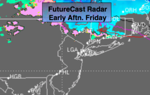
A warm up will begin today, the first full day of Winter, as the high slips off the coast and the return flow brings up milder air. Skies will be cloudy. A spot shower can’t be ruled out. Well to the North (on the cold side of the warm front) a bit of wet snow/sleet and rain will fall. FutureCast radar above shows the mix.
On Saturday, ahead of the approaching cold front, balmy readings are expected with scattered showers In fact, Saturday’s highs will feel more like Spring getting into the 50s. The cold front will move through Saturday night. Sunday will be partly sunny and cooler.
Now on to Christmas Eve Night and early Christmas morning. A low will form off the Mid-Atlantic coast. It looks as though (with the latest computer guidance) that the developing storm will form to0 far North and East to be a big player. A bit of light snow or snow showers is possible. If an inch falls by Christmas morning it will be considered a “White Christmas”. Again, it’s not looking like a big deal, but the chance of a White Christmas is there!
Stay tuned..
Today:
Mostly cloudy. Milder. A few showers possible. Well North of the City a mix is possible. Highs in the 40s, 30s well North. East to Southeast winds at 5-10mph.
Tonight:
Cloudy. Areas of light rain. Milder than recent nights. Lows in the 40s in the City, the 30s inland. West to Northeast winds less than 5mph.
Saturday:
Cloudy with showers. Balmy. Highs in the upper 50s.
Christmas Eve:
Mostly sunny. Cooler. Highs in the mid 40s.
Christmas Day:
Early morning snow showers, otherwise mostly sunny and colder. Highs in the mid 30s.
Tuesday:
Mostly sunny. Cold. Highs around 30º.
Keep it here for a no nonsense, no hype forecast.