Synopsis:
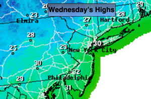
An Arctic front will move through the region this evening with scattered snow showers and strong wind gusts. Once the front passes through the coldest air of the season so far will rush in. A bitter blast will arrive tonight and Wednesday. Temperatures will remain below freezing for highs on Wednesday with a biting wind. Wind chills will be in the teens.
An Alberta clipper will move into the region Wednesday Night and early Thursday morning. A period of snow showers or light snow is likely. A coating of snow is possible in spots by Thursday morning.
Another round of snow showers is possible Friday night as a weak disturbance moves through. This system is moving rapidly and should not be a be deal.
The cold will moderate some by the weekend with readings reaching the lower 40s by Sunday. A decent amount of sun is expected.
Stay tuned.
Tonight:
Spotty snow showers this evening otherwise partly cloudy, windy and much colder. Lows in the mid 20s in the City, the upper teens inland to 20s inland. West to Northwest wind at 15-30mph with higher gusts.
Wednesday:
Partly sunny, windy and brutally cold. Highs in the upper 20s to around 30º. Wind chills in the teens. West to Northwest winds at 15-30mph with gusts up to 40mph.
Thursday:
Morning snow showers, otherwise partly sunny and cold. Highs around freezing.
Friday:
Partly sunny. Highs in the lower to mid 30s.
Saturday:
Mostly sunny. Highs in the mid 30s.
Sunday:
Partly sunny. Highs in the lower 40s.
Keep it here for a no nonsense, no hype forecast.