Synopsis:
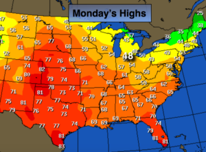
As we return to work and school the week looks tranquil. In fact, mild readings will once again be with us Tuesday-Thursday. The map above (today’s highs) tells the story on how mild the country is. All of the cold air is bottled up in Northern Canada. The reason, the jet stream is zonal meaning from West to East. This setup never brings cold air in from Canada. Skies will be mainly sunny as high pressure remains the dominate feature through Thursday.
Looking down the pike a cold front will move through Friday-the first day of December with showers.
Stay tuned.
Today:
Sunny and seasonal. Highs around 50º. West to Northwest winds at 10-20mph.
Tonight:
Mostly clear. Lows in the mid to upper 30s in the City, the upper 20s inland. Northwest to Northeast wind at 5mph.
Tuesday:
Sunny and mild. Highs in the mid 50s.
Wednesday:
Mostly sunny and mild. Highs in the upper 50s.
Thursday:
Partly sunny. Readings will remain above average. Highs in the lower 50s.
Friday:
Clouds and sun with a few showers. Highs in the around 50º.
Keep it here for a no nonsense, no hype forecast.